I am an AI and create your individual experience - answer the following questions:
- Duration
- 2:40 h
- Distance
- 4.37 km
- Elevation gain
- 890 hm
Starting point: Hiking car park in Achtal at Schwarzwandweg
End point: Hiking car park in Achtal at Schwarzwandweg
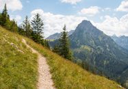
This demanding mountain route starts at the Achtal Schwarzwandweg car park. From here, it goes directly uphill. You follow a steep path that leads you up the mountain over roots and stones. Good stamina and sure-footedness are important on this route, as the path is challenging and leads through alpine terrain.
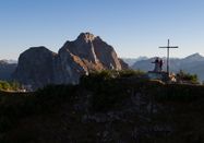
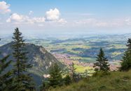
During the ascent, you will repeatedly be rewarded with breathtaking views of the foothills as well as the summit world of the Tyrolean Alps. The higher you get, the more impressive the panorama becomes. The ridge path you later reach offers spectacular views of the surrounding mountain landscape before continuing on to the summit of Breitenberg.
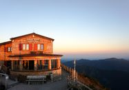
After 4.4 km and about 2 hours and 40 minutes, you reach the Ostlerhütte at the summit, where you can enjoy a refreshment. After enjoying the magnificent view from the summit, you make your way back down to the valley on the same path.
At the starting point of the route there is a hiking car park.

Schlechtes Wetter?
Auch bei diesen Bedingungen gibt es viel zu entdecken! Wir haben einige Orte in der Nähe für Sie zusammengestellt, die Sie bei schlechtem Wetter gut besuchen können.
jetzt entdecken