I am an AI and create your individual experience - answer the following questions:
- Duration
- 4:45 h
- Distance
- 81.12 km
- Elevation gain
- 1110 hm
Starting point: Tannheim
End point: Tannheim
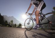
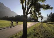
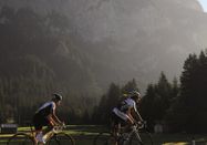
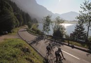
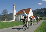
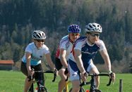
The Tannheimer Tal has long been known among cyclists, as in 2001 the peloton of the Austrian Cycling Tour passed through the valley. In 2005, the professionals of the Bavarian Cycling Tour arrived on Tyrolean soil at the opening stage and were rewarded with the mountain classifications Tannheimer Tal and Jungholz. Even professionals noticed the scenic charms of the "probably the most beautiful high valley in Europe". Lush green meadows, the Haldensee lake and beautiful mountain scenery accompanied the pro riders on their racing kilometers. Thus, the Tannheimer Tal has also proven itself as an ideal region for targeted training or extended routes. "The Tannheimer Tal is an ideal starting point for long road cycling routes to the surrounding regions such as Lake Constance or the Arlberg," says Michael Keller, managing director of the Tannheimer Tal Tourism Association and former Austrian national mountain bike coach. Cyclists find a broad range of accommodation in the Tannheimer Tal in addition to the ideal starting point. From 5-star hotels to private rooms you can choose your accommodation. After a beautiful ride, let your soul dangle and recharge with new power. - The Tannheimer Tal
Road cycling booklet "The most beautiful road cycling routes around the Tannheimer Tal".
Available in all tourist offices in the Tannheimer Tal and Jungholz.
Wonderful opportunities to stop and refresh along the route.
Start at the tourist information in Tannheim heading east. At the Grän/Haldensee junction, turn left onto L261 and go through the Engetal valley to the former customs office Fallmühle descending to Pfronten until the main road. Turn left and in the town center after a 90 degree left turn, turn right towards Füssen. In Pfronten-Meilingen turn right towards Falkenstein. There is an ascent to the Falkenstein ruin. Once at the top, the highest point of the route, take the same way back and turn right at the junction. At the roundabout turn right and follow the road to Weißensee. At the end of the lake turn right to Alatsee. Along the lakeshore through the Faulenbachtal valley to Bad Faulenbach and further towards Füssen, heading to the historic old town. In the town center of Füssen continue towards Munich/Augsburg. In Alterschrofen turn left towards Schwangau, passing the estate of the Thurn and Taxis family. At the junction turn left to Schwangau. In the town center of Schwangau turn right towards Augsburg. At the town’s end turn right to Hohenschwangau. In Hohenschwangau keep right towards Pinswang and via the Alpsee to Pinswang. ATTENTION: approx. 1.5 km of natural road! In Pinswang keep right to the Lech bridge and there turn left to Vils and continue towards Pfronten. In Pfronten Steinach after the church turn left towards Tannheimer Tal through the Engetal valley on L261 to Grän. At the Grän/Haldensee junction turn right to Tannheim back to the starting point.
Parking at the Neunerköpfle cable car in Tannheim – fee required.
By train to Sonthofen, Pfronten/Ried or Reutte, then further by bus to Tannheim.

Schlechtes Wetter?
Auch bei diesen Bedingungen gibt es viel zu entdecken! Wir haben einige Orte in der Nähe für Sie zusammengestellt, die Sie bei schlechtem Wetter gut besuchen können.
jetzt entdecken